
Your job is to work on a gas pipeline, yet before you start it’s critical for safety to know exactly where everything is underground. So you open your scanned pdf of a hand-drawn sketch of what should be underground, and hope it’s reliable. Why? Because that’s just how PSE&G has always done it.
“We’ve been doing our gas asset records the same way for a 100 plus years – using a measuring wheel, a piece of paper and a pencil,” said Chris LaRossa, PSE&G district manager, regulatory policy & procedure, Gas Distribution & Field Construction. “The sketches usually contain reference points, such as a utility pole or a corner store, yet those things move over time.”

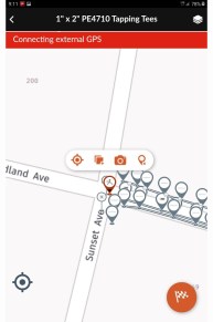
To leapfrog into the 21st century, Gas Operations is poised to launch a mobile application, Locusview, which lets crews use computer tablets to quickly identify underground material for both tracking and tracing. Locusview relies upon industry standards for material traceability, creating efficient storage of data and information, as well as the ability to retrieve it easily.
The versatile smart technology allows for high accuracy GPS digital mapping and it also captures key information on the gas pipe or fitting being placed in the ground. LaRossa said, for example, if an issue arises with a specific fitting, Locusview will allow PSE&G to quickly identify if we have any others installed in our system and take action to address the risk and avoid a potential incident.
“This is a major undertaking that completely changes the way we do things, yet has massive benefits,” LaRossa said. “The plan is to roll it out in phases, work out the kinks, and then get it into the hands of all of our inspectors and street leaders.”
LaRossa said the project deployment has been delayed by the pandemic, but he hopes to launch it by the end of the year starting with the Gas System Modernization Program.
Gas Operations Vice President Joe Forline praised the effort and said, “We’re incorporating technology like never before to better serve our customers and to reduce mundane tasks so our team members can keep their focus on safety, operational efficiency, customer needs and innovation.”
Project Lead Stephen Daniele, from the Smart Operations Design Engineering and Geospatial Solution group in IT, said that while PSE&G is licensing the ready-made Locusview, months of work has gone into specific customizations so that Locusview collected data integrates easily with PSE&G’s GIS system. PSE&G also installed technology that allows for on-the-spot correction of GPS data accuracy.
One huge benefit to the work on the GIS system, Daniele said, is streamlining a mapping process that now takes 15 to 45 days. Currently, once a paper record is submitted, editors have to go into the GIS system to create digital maps. The digital copy only is as accurate as the original hand-sketched paper copy, until it is updated over time. Under Locusview, accurate information is available for use within one week, with near-instant updates.
Other smart tech benefits include:
- Increases safety and efficiency per job while decreasing the need for repetitive manual processes.
- Improves field work validation.
- Improves back-office view of field work and two-way communication.
- Streamlines approval processes.
- Eliminates paper records.
- Requires minimal training.
LaRossa said the product will be rolled out in stages, over the next year.


Add comment